Robin's Ancestry
![]()
|
|
||
|
Lanark Town |
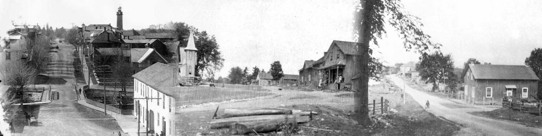
Watson Corners Circa 1900 |
McDonalds Corners |
To Hoods Corners by Way of Watsons Corners.
By Ed Somers 1985 edited 2005
(Long Read)
Where, on the map, is Hoods Corners? Watsons Corners is on the map. Both of
these places are located in Ontario. To be even more specific they are in
Dalhousie Township, Lanark County in Ontario, just a little to the southwest of
Ottawa. It takes about one and one half hours to drive from the Ottawa
airport. At least that is how long it took me to drive back from Hoods Corners
after I had found the place.
There is the rub. I was looking for Hoods Corners. It had shown up in the
story of the Hood family and since a lot of Jack family are part of the story, I
wanted to get an eyeful of the place that my ancestors had lived when the first
came to Canada on the sailing ship "Prompt" way back in 1820.
On November 5, 1985, I was sent to Ottawa on a business trip that was to last
couple of days. It turned out that I had some extra time on the second day
before I had to fly back to Manitoba. The opportunity was there so I took off
to try to find Hoods Corners.
With the help of the good people at the office in Agriculture Canada, I was told
to head out west on the Queensway until I saw the sign for Carleton place; then
to find the road to Lanark; then the next stop was to locate the last point
shown on the map, Watsons Corners.
Here's the story as I dictated it as I drove into the countryside.
I have just crossed the Mississippi River in Lanark County after driving down
from Ottawa. When you drive through this country you see open spaces without any
evidence of human habitation either now or even in the past. Then you'll come
across vigorous looking farmsteads.
There are rock outcrops within most of the hill cuts along the highway. It
gives the impression that the soil is very shallow. Between the rocky areas
there will be a swamp or in some cases an area of decent soil that is
cultivated. Interspersed with these are the homes of what would appear to be
non-farm residents, many quite attractive. They show evidence of a degree of
affluence and the wish of some city dwellers to get out of the city and into the
country.
The fences along the right-of-way are page wire. Into these run split rail
fences, many in good condition. I wonder when those rails were split and
carried to where their role of keeping the cattle and horses out of the fields,
or of keeping them in the fields.
I have just gone through another rock cut, obviously limestone. It shows the
horizontal lines of an ancient sedimentary deposit. The countryside along the
end of the road is getting rougher. On the side of the road is a two acre field
of corn resting in a small hollow of soil between the rocky areas. There is
evidence of only small areas of arable land. In these spots it is often wet.
All along the route there are cedars growing --- many cedars, beautiful cedars,
and again there are some fine looking cornfields. Harvesting has been completed
for there are only the remnants of the crops still in the fields. They have
been lifting the cobs, probably threshing corn through a combine with only the
kernels going onto the bin. There is no evidence of crib storage. There are
just the odd silo pushing its way into the sky, the rural skyscraper you will
see outside the edges of cities or large town's.
Buildings are usually brick houses, tin sheeted barns or vertically sided
barns. Once in a while there will be a log barn or a group of old log
buildings. Some are evidently still in use. Close by are dairy cows or
beef-on-the-hoof resting, chewing their cuds or quietly grazing on the last
grasses of the fall.
Another cornfield! Is this was one still in the process of being harvested for
some of those stalks still stand. I suspect it is the field that I saw on the
way back that had a combine busy hammering through the standing stalks,
stripping the cobs and sorting the golden kernels into the hopper. A truck
waiting patiently by the edge of the field until it is its turn to carry out its
part in the gathering of the harvest. The same steps that my great grandfather
Willie and my great-great-grandfather William Jack in both cases - would also
have done though the crops would most likely be oats or a little barley or maybe
even a little wheat and the way of harvesting was a scythe and a flail and the
winnowing basket.
You find an answer only to get another question. What grains did the Jack
family grow when they lived in Lanark County from 1820 until 1832? From the
looks of the land it must have been a difficult way to raise any food and the
trees were much greater in both abundance and in size. Since these were Scots,
it is likely that the basic potato played a major part in keeping hunger from
the door. One will have to look further into the history books and the stories
that have been written to find the answers.
Note; Information passed down indicates that the Jack family and likely other
families in Dalhousie township left for Simcoe because they were slowly
starving.
From the appearance of the majority of the farms, the dairy industry is the
mainstay of the present farmers in this part of the county.
I'm now driving down No. 7 highway from Carleton Place heading towards Toronto.
Shortly I want to turn off towards Lanark and thence down to the road that would
lead me to Watsons Corners. There I will try to locate someone who might know
where Hoods Corners might be located.
On the side of the road is a good example of what the Westerner calls on Ontario
barn. There is the stone base plastered and cemented together with a tall frame
above it and sides covered with vertical boards. The fields around the barn
have been fall ploughed. Next to these ploughed fields are others with grazing
cattle and a few horses living what appears to be a life of leisure.
The tamaracks are changing colour. The bright yellow of their needles in sharp
contrast to their evergreen cousins. The dominant tree seems to be the cedar.
They are everywhere.
Before leaving Carleton Place, I visited the town office where the clerk gave me
directions to Lanark. Across the street was store with tartan shirts in the
window. I looked into the store to see if there were any local books that would
add colour and some facts. The Lanark Book by Morton Brown was not in stock
however the operator said he would get a copy and send it to me. He also gave
me the name of a local Renfrew lady who might have some further history
material. There is some evidence of localized industries beside the road was a
factory that was making fence posts and apparently also makes fences of some
type. And it looks as if the material of cedar or perhaps tamaracks.
Just passed through Ferguson Falls, a very small village beside what must be the
Mississippi River -- Ontario style. Besides the road and stretching into the
fields are more fantastic rail fences. In the village were log houses with the
logs showing and evidently still lived in for the windows were lined with
curtains. The road splits the village right down the middle.
Just outside of the village were some apple trees with the apples that were left
struggling to retain their hold on the leafless branches.
Now into the town of Lanark where I promptly got lost. After a quick turn
around in the road, I return to the village. On the way I passed a fairly
substantial sawmill down over the crest of the hill.
In Lanark I pulled into a candy store that made homemade fudge. I asked for
directions. Oh my! The chocolate smells and delicious look of candy, fresh
looking candy, with was too much for me. I bought some bars of fudge: maple
walnut, chocolate mint, rum and butter and one more than escapes my taste
palette for the time being.
One of the clerks, a young lady, indicated she had heard of Hoods school but she
did not know if it was the same as Hoods Corners are not.
After travelling for another few miles, I'd turned into Lanark County road No.
8. It seems to hit in the northwest off of No. 511. The sign indicated eight
kilometres to Watsons Corners.
There it is. Watsons Corners located on a hill. It is not very large to say
the least. There are some older buildings, one that looks as if it had been a
livery barn, another with the ever present veranda roaming around the outside.
It does not looked like the most progressive place of the world. Over on the
other corner is Hannah’s store, with the another sign over the other side of the
building stating that it is also MacKenzie store.
I turned north-westerly, I think. The directions are fading because there's no
sun to come through the clouds and give a sense of direction. From the maps
that I remember, the survey lines do not run in the North-South-East-West line's
that the western country is used to. The township is surveyed on the diagonal
On the south of the road United Church, the St. Andrews United Church of Watsons
Corners, and across from it is the community hall that has an historic sign
recognizing Dalhousie Library.
Following is thus inscription:
"In 1828, eight years after the original settlers of this area, the St. Andrews
Philanthropic Society founded the first public library within the old Bathurst
district. A log building known as the St. Andrews Hall housed the library for
many years. The Earl of Dalhousie, governor in chief of Canada, 1822 to 1825,
subscribed money for its support and donated a number of books. Thomas Scott, a
pioneer settler was the first president, and among the distinguished citizens
who subscribe were the right Rev. Charles Stewart, Anglican bishop of Quebec and
Archdeacon John Strachan, later first Anglican Bishop of Toronto. The library
was incorporated in 1852 and the number of the original books are in the
present community hall."
There is no sign of their being anyone around, not a soul.
Driving through part of the town, I finally found one person, a lady walking
toward the centre of the Corners. She gave me directions to the cemetery and to
a place further down the road about two miles, to what is known as Hoods
Settlement.
The village is made up a both modern and older homes with some of the edge of
the ancient vintage having the bedraggled look that is not unfamiliar with
visitors to the prairies.
The time is getting close to 2:30 in the afternoon and I have to fly out at 6:35
that means four hours from now. There isn't much time left to check out much
more. I'll find the cemetery, check it out and see if I have time to go to the
place that the lady said was Hoods Settlement.
In the graveyard I looked at the gravestones and these are some of the readings.
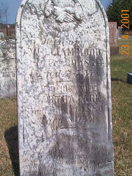
William Hood died 1874, at age 74 years, also his wife Martha Park, died Jan. 21, 1880 at age 80 years. Note: It is my belief that this is the William Hood, son of James Hood of the “Prompt” and progenitor of the Hoods that live at Basswood, Manitoba.
![]() View Family
Group Sheet of William HOOD
View Family
Group Sheet of William HOOD
![]()
As I walked through the graveyard, there were a number of other names: Fair,
McInnis, McDonald, Whyte, Crosby, Park. There are quite a few of this last name.
The oldest stones are in the centre of the graveyard. This is where I found the
Hoods stone, a large stone compared to many of the others stones found in the
same area.
I was looking for any sign of the name Jack on any of the old stills. However
this was not to be one of the first run through. I found no name was Jack.
There was a Gemmill, Penman and then as I was working my way back to the car, I
found a stone with the Jack name on it.
Here is what was on the marker.
Henry P. Barry 1820 - 1898 and his wife Susana Jack, 1823 - 1900.
Albert E. Barry 1893 - 1893
Christina Barrie 1894 - 1897
Dalbert 1903 -1904,
James Barry 1856 - 1932 and his wife Gertrude Prince 1864 - 1962.
This was the first indication of anyone with the Jack surname. This would
reinforce some of the information that Marie Tryon had located in her research
of the Perth news files. It is probable that Susana Jack is a descendent of the
James Jack listed on the “Prompt.”
Other names were Barr, McArthur, Paul, Labelle.
After leaving the cemetery, I went to the junction where the McNicol or
McNichols lived. There is a Baptist Church on the corner. It is called
Dalhousie St. James Baptist Church. I learned that this church had been sold to
a lady and nothing and happened to it since that time. There's no indication of
a burial ground associated with it. There are a number of houses at the corner
so I wouldn't be surprised if this is Hoods Corners.
Just before I was going to leave away I decided drop into one of the places to
see if anyone was about and see if I could get any more information from them.
I'm drove up to the house close to the corner, the home of Mr. and Mrs. Pretty.
Mrs. Pretty was formerly a McNichols. I went into the house with them and they
said that this indeed was Hoods Corners and the house that we can see across the
pond was the Hoods house where Arthur McNichols and his wife Winnie lived. She
suggested that I drive over there and have a visit with them since they would
know much more than she did.
Across the pond I drove to the log house known as the Hood House.
Winnie McNichols showed me through the log house which she suspected to be at
least 150 or more years old. McNichols Sr. had lived in the house. Apparently
they had moved there in 1903 until they had built the house that the Pretty’s
now live in. The house stood empty for about 25 years. Along came the
Depression of the 1930s. Arthur and Winnie wanted to get married and they
needed a place to live that was not too expensive. Winnie agreed to live Hood
house. It had been used as a shop for making axe handles. A new roof was added
and a kitchen was put on the side of the building.
The present structure is a neat well-kept building with an additional room added
plus divisions in the second story which included waterworks. The main or log
part of the house has three rooms on the ground floor, a kitchen living space
with the stove, a parlour and a bedroom. Upstairs had been one large room at the
head of the stairs.
Down below the house is a spring that never stops running. It is now enclosed
in a concrete structure. The water is piped up to the house and by gravity down
to the barn. The overflow goes into the pond I crossed.
Across from the spring and up the rise of across the other intersecting road is
Hoods school, now a summer home for outsiders.
Up behind the Hoods house is a rocky knoll, interspersed with grass and shrubs.
It must rise about 50 feet. The McNichols invited me back, particularly, if
Arthur could be at home to talk with me. On this occasion he was out hunting
deer with his son, a member of the Ottawa police force. Thus this visit must do
for they are retired people and are very good to talk with.
Apparently before the McNichols purchased the farm, the land about had been all
the people by the name of Park. I guess it is not coincidental that William
Hood was married to a Park. Mrs. Meg Nagle indicated that most of the land
around Hoods Corners had been owned by people called Park.
The time was 3:30 and I had a flight to catch so I had to take flight as well.
I was back to the airport with about an hour to spare since I did not get lost
and I had no difficulties.
I had found some more information. This was the country where my
great-grandfather William (Willie) Jack played as a little boy. He had just
arrived from Scotland and then left the district as a young man to settled in
Simcoe County, then to move to Bruce County in 1869 and finally to Strathclair
Manitoba in 1877.
There is more story. And someday someone will add to this article.
Ed Somers — November 12 1985
Re-entered June 2002
Edited November 2005
Links
Created 12 June 2016 with RootsMagic Genealogy Software